


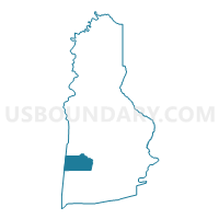
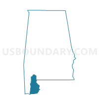
Barnwell Community Center, Baldwin County, Alabama
About
Outline

Summary
| Unique Area Identifier | 521200 |
| Name | Barnwell Community Center |
| County | Baldwin County |
| State | Alabama |
| Area (square miles) | 64.61 |
| Land Area (square miles) | 22.06 |
| Water Area (square miles) | 42.55 |
| % of Land Area | 34.15 |
| % of Water Area | 65.85 |
| Latitude of the Internal Point | 30.41628560 |
| Longtitude of the Internal Point | -87.90820290 |
Maps

Graphs
Select a template below for downloading or customizing gragh for Barnwell Community Center, Baldwin County, Alabama


Neighbors
Neighoring Voting District (by Name) Neighboring Voting District on the Map
- Fairhope Civic Center, Baldwin County, AL
- Magnolia Springs Wesleyan Church, Baldwin County, AL
- Point Clear St. Francis Church, Baldwin County, AL
- St Philip Neri Church, Mobile County, AL
- St. Michael Catholic Church, Mobile County, AL
Top 10 Neighboring County Subdivision (by Population) Neighboring County Subdivision on the Map
- Foley CCD, Baldwin County, AL (48,089)
- Fairhope CCD, Baldwin County, AL (25,894)
- Theodore CCD, Mobile County, AL (23,380)
- Bayou La Batre CCD, Mobile County, AL (10,209)
Top 10 Neighboring Place (by Population) Neighboring Place on the Map
Top 10 Neighboring Unified School District (by Population) Neighboring Unified School District on the Map
Top 10 Neighboring State Legislative District Lower Chamber (by Population) Neighboring State Legislative District Lower Chamber on the Map
- State House District 95, AL (61,642)
- State House District 94, AL (59,763)
- State House District 105, AL (44,279)
Top 10 Neighboring State Legislative District Upper Chamber (by Population) Neighboring State Legislative District Upper Chamber on the Map
Top 10 Neighboring 111th Congressional District (by Population) Neighboring 111th Congressional District on the Map
Top 10 Neighboring Census Tract (by Population) Neighboring Census Tract on the Map
- Census Tract 114.01, Baldwin County, AL (10,632)
- Census Tract 113, Baldwin County, AL (4,487)
- Census Tract 111.02, Baldwin County, AL (3,715)
- Census Tract 9900, Baldwin County, AL (0)
- Census Tract 9900, Mobile County, AL (0)